As eruptions of highly active volcanoes continually leave their mark on the landscape of Iceland, it has become a land of constantly renewing landforms – strikingly different to most places and countries where landforms remain unchanged for hundreds or thousands or millions of years.
One of the most interesting places to visit to understand and experience such endless rebuilding, renewal and transformation is Lakagígar. The volcanic eruption that started in June 1783 lasted for eight months and became the second biggest lava flow in the history of the planet Earth. The glowing magma from the eruption submerged about 14 square kilometres of land, transforming the landscape from the southern region of the Highlands of Iceland all the way down to the coastline.
This was an event that not only transformed landform but also ruined many farms, killing both livestock and people. As such, the eruption had a significant impact on the continent of Europe for years after.
- See also: Private Landmannalaugar Photo Tour
What to See in Lakagígar
Before the eruption, the small mountain called Laki stood tall on the Highland’s black sand surrounded by a few other mountains. During the eruption, a large fissure opened on both sides of the mountain, stretching from the glacier Vatnajökull to the southwest through Laki and about 25 kilometres farther.
As is often the case with an eruption in Iceland, the fissure turned into several erupting craters as it progressed, shaping and redefining the whole area around the small mountain Laki. The outcome was the creation of a stunning 25 kilometres of craters, each with its own shape and character.
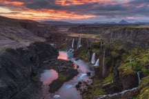
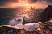
 Tjarnargígur crater is one of the most compelling craters among the Lakagígar craters. Photo by: 'Einar Páll Svavarsson'.
All of the craters are located lower than Laki, making the peak of Laki the perfect place to view this spectacular sight. The craters on the east side have the Vatnajökull ice cap as their background, whereas those on the west side stand before the river Skaftá and the mountain ridge Fögrufjöll.
The lava that flowed southwards is now mostly covered with green moss and stretches as far as the eyes can see. It is the landform that surrounds the craters in addition to layers of tephra and highland vegetation, moss, and related plants.
- See also: Landmannalaugar Photography Day Tour
Why is Lakagígar Attractive to Landscape Photographers?
If you are looking to photograph unusual and exciting landscapes, the Highlands of Iceland provide infinite resources. The Highlands cover nearly half of the island and is uninhabited.
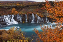
 The Lakagígar area is large and has infinitive photographic possibilities. Photo by: 'Einar Páll Svavarsson'.
Lakagígar and the many surrounding natural wonders – such as craters, lava, black sand, Highland vegetation, mountains, rivers, creeks, lakes, black and red rock formations, and small ponds – are all reasons to visit the place as a photographer.
The unique landscape of Lakagígar is a novelty for most photographers. A day-long drive through it, with an experienced guide, is an otherworldly experience for anyone. Learning the local stories about the eruption and the fascinating geology of the area is, of course, an additional advantage.
Drive to Lakagígar
Like all places in the Highlands of Iceland, Lakagígar is only accessible from the middle of June until the beginning of October. In the winter, the craters, the road, and the surrounding mountains are all covered with snow and not particularly interesting for photography.
The distance to the craters from Ring Road Number 1 in the south is 42 kilometres. The road is a typical Icelandic Highland road — a dirt road traversing two to three unbridged rivers as well as the Hellisá river, which can be quite big and unpredictable.
For this drive, we always recommend a good 4X4 vehicle and proper preparation. The best option for people interested in photography is a tour with an experienced photo guide and a Highland driver.
About the author: Einar Páll Svavarsson is a landscape photographer based in Iceland. You can find more of his work on his website, or by following him on 500px.
Would you like to visit the Lakagígar craters and the mysterious Icelandic Highlands? Join us on a one-of-a-kind Camping Adventure into this mysterious and enchanting landscape!

Einar Páll Svavarsson is an Icelandic Political Scientist travel and photo guide and landscape photojournalist
Einar Páll has been interested in landscape photography for decades and taken thousands of photos all over Iceland. In summer and winter, by the coast and in the highland, in canyons, by waterfalls, close to erupting volcanos as well as top of freezing cold glaciers. In addition to photographing natural wonders, Einar also regularly takes photos of the peaceful and beautiful small fishing villages around Iceland as well as his beloved hometown Reykjavík.
Einar Páll has traveled extensively in Iceland in all seasons and written hundreds of articles and published thousands of photos about places in Iceland and natural wonders posted on his website. Einar Páll is one of the most experienced people in Iceland when it comes to traveling in Iceland and finding exotic places of interest to photographers and is also a fully licensed tour driver with emphasis on highly modified 4X4 vehicles.
Einar also has good knowledge of Icelandic history, geography, and geology. Apart from Iceland Einar has lived in Toronto for a year and six years in San Diego California.